More Detailed Geology of the Surrounding Area
A few years ago the Dumpling Times included an article about the geology of the area. We thought visitors to our website might be interested in reading it too and you can do so by scrolling down. It is a reasonably lengthy article so keep scrolling!
Life at the Edge — a Tale of More Than Two Terranes
written for the Dumpling Times by Jane MacDougall
If you are living in the Gartocharn area, you are living close to the edge of an exotic terrane!
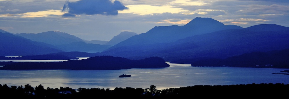
At 142 metres high, “the Dumpling” ‑ or Duncryne to give it its proper name ‑ may not quite match up to Everest’s height; but, its distinction as the highest ground in the immediate vicinity of Gartocharn makes the task of climbing it well worth the effort.
It acts as a spectacular viewpoint for surveying the landscape to north and south. To the north, the islands of Inchcailloch, Torrinch, Criench and Inchmurrin ‑ like partly submerged humps of a “Loch Monster” — run across Loch Lomond from the high ground of the Conic Hill at Balmaha. Beyond this line, the ground is high. It is dominated by Munros ‑ Ben Lomond, Ben Vorlich, Ben Vane and many more, all visible from Duncryne — and by many Corbetts. To the west, but still north of our line, there is the rugged topography of the Arrochar Alps. This whole region of high ground is the southern edge of what we call the Scottish Highlands.
In contrast, the area to the south of the Conic line, girdling Duncryne and beyond, is low. A few bumps of higher ground have their own story to tell; but there is nothing which resembles the topography of the Highlands. We call this part of Scotland the Midland Valley. Physical geographers tell us we are looking at “two terrains”, two tracts of ground with different physical features. Tradition has it that the two terrains are separated by a major fracture in the rocks known as the Highland Boundary Fault.
A good friend of mine and fellow geologist, Dr Stuart Monro, always introduces his students to the study of field geology with the words, “Geology is like Forensic Science. The clues are there, in the rocks themselves.” So, to answer the question, “Why do two very different terrains lie alongside each other on opposite sides of the Highland Boundary Fault?” we will take an imaginary walk along the shores of the east side of Loch Lomond, and look at the rocks.
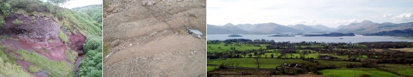
From nearly as far south as the Campsie Fells and the Kilpatrick Hills, the low ground running northwards to the Conic is composed of rocks which are reddish in colour. Some are sandstones, and others, with a mixture of coarse and fine grains, are known as conglomerates. They are part of a series of beds known as “The Old Red Sandstone” and they have all the hallmarks of rocks deposited by flash floods in a Devonian-aged desert. The red colour is due to the presence of an iron oxide, hematite, coating the quartz grains. This mineral forms only under arid conditions. Palaeomagnetic studies indicate that this desert lay at a latitude of about twenty degrees south of the equator at the time the flash floods deposited the sediment in the channels of a wadi.
The closer we get to the Conic, the steeper the dip of these beds becomes. For many years it was assumed that this was due to drag imposed on the rocks by the ongoing action of the Highland Boundary Fault as it displaced rocks in a downward direction to the south. It was also assumed that, if a borehole were drilled through these rocks, the Highland rocks would be found at depth. We now know that this is not the case. Nor is the fault which lies immediately to the north of the Conic the Highland Boundary Fault!
The Highland rocks, or Dalradian rocks, are slates and schists. They have a shiny, silvery-green colour and are often cut by white quartz veins. They show evidence of having been folded and refolded during perhaps six phases of deformation in which they were compressed, stretched and altered as areas of continental crust collided in a mountain-building event known as the “Caledonian Orogeny”. They are part of an ancient mountain chain which was once as extensive, and in part almost as high, as the present day Himalayas are. These Highland rocks are older than the Old Red Sandstone rocks at Balmaha by about two hundred million years.
When mountains are built and uplifted, their weathering and erosion produces a huge amount of sediment which is carried to low ground by fast-flowing mountain torrents and eventually deposited as the raw materials for future rocks. Surprisingly, at Balmaha, there are absolutely no pebbles of Highland rock-origin in the conglomerates of the Conic or in the conglomerates in the area above and around the pier. If the Highlands were the original source area for the waters and sediments of the wadis in Devonian times, at least some grains should have the characteristics of the slates and schists, but they don’t.
The other problem is, that as we walk north from Balmaha, we have to reach the northern side of Millarochy Bay before we are into truly recognisable Highland rocks. Between the Conic and Millarochy Bay there is an area of ground which is part of neither the Highlands, nor of the Midland Valley. We refer to it as “The Highland Border Complex”. This tiny pocket of land turns out to have quite an amazing story to tell … but, first, we need to digress.
Within the Earth, energy in the form of heat results in the formation of convection currents in the mantle. On a long time-scale part of the upper mantle, not far below the crust, flows like a fluid. This area, the asthenosphere, allows blocks of the overlying rigid lithosphere (partly mantle and partly crust) to move slowly across the Earth’s surface. Such blocks are called “Plates”, and the study of their movements is called “Plate Tectonics”. Through time, plates converge, diverge and slide past one another as new oceans grow, and old oceans close. When continents collide (because an ocean has closed) mountains are built. Unlike oceanic crust, which is continually being recycled through geological time, continental crust is not destroyed by plate tectonic processes. Once formed, it remains and new areas accrete on to its margins by further collision processes. From time to time, all of the continental land masses come together to form giant super-continents. When these are eventually torn apart by rifting, small areas can break off at the edges, near the rift faults. Such fragments, usually of restricted size, are called “terranes”. “Exotic terranes” leave their parent continent and never return to it. They eventually become part of a new continent. The geological history of each exotic terrane is distinctive, and differs from both that of its parent continent and that of its new host. Its properties act like fingerprints, and provide clues which enable us to track some of the story of its origins and its travels. The clues can be straight-forward ones like the presence of unique fossil assemblages, or distinctive igneous rock-types. Often, though, the clues are more complex and need much study before their significance can be appreciated. This is true for the rocks just north of Balmaha.
The landscape we can see from the top of the Dumpling may indicate there are two terrains, but these are made up of at least three or four, and probably more, exotic terranes. When terranes accrete on to each other, or to a new host continent, they are said to “dock”. As time goes on, the original terranes become covered by younger rocks, and their identity and the junctions between them, can be obscured. In Figure 1, the Highland Terrane (which itself has a complex early history, a story beyond the scope of this article) is labelled (1). (3) is the Midland Valley Terrane. It, too, is an area with a complex early history, much of which has yet to be unravelled. It may, in fact, be a composite terrane. It seems increasing likely that the basement rocks in the Midland Valley are similar to some of those we see exposed in our tiny area of Highland Border Complex, labelled (2) just north of the Conic Hill. It also seems likely that there are no Highland rocks at depth in the Midland Valley. The two thick dark lines on the diagram indicate exposures of a rock called serpentinite. Its presence indicates the position of major faults. It is the more northerly one which, along the east shore of Loch Lomond, represents the Highland Boundary Fault, and not the serpentinite which lies to the immediate north of the Conic.

In this small area (2) there are two sets of very significant strata. Immediately south of Millarochy Bay there are some grits. In various localities along the north side of the Midland Valley terrane, rocks equivalent to these grits have produced fossil evidence for their age and origins. These rocks are younger than the Highland rocks, and older than the Devonian rocks. Like the rocks of the Conic, there are no fragments of Highland material in them. The reason for this is that they formed far away from the Highland Terrane, in a very different part of the world. Progressively, the various terranes came together, and by the upper part of the Devonian, the Highland Border Complex (2) had docked with the Highland rocks (1). The evidence for this comes from another set of beds in area (2). Just north of Manse Bay, beside the loch shore, there are exposures of red rocks which contain abundant pebbles of Highland rocks. These red conglomerates, like the Conic rocks, are of Devonian age but they are a bit younger than the actual age of the Conic conglomerates. It certainly looks as if the high ground of the Highlands was the supply source for these. Thus, terranes (1) and (2) must have accreted by this time. The Midland Valley terrane (3) docked shortly after this on to the assembled terranes.
One glance at the geological map of Scotland is enough to convince most people that Scotland’s “assembly” has been anything but simple. The oldest rocks in Britain are to be found in the northwest corner of the mainland, and in the islands of the Outer Hebrides. Four major faults, and countless smaller ones, cut the rocks, and displace once-adjacent rocks by many miles. Some former fault movements were of the scale of the present-day San Andreas Fault, and would have caused earthquake disturbances to match. The most recent volcanic activity in the UK took place in areas like Skye, and Mull, and Rum – a knock-on effect of the opening of the North Atlantic. The rocks that make up Scotland, and which give it its varied and much-admired scenery, are full of geological history because most of them have originated on the edges of tectonic plates. It’s in such areas that tectonic activity takes place and geological history is written.
The geology of the area around Balmaha has been studied for very many years. It is an area of vital significance in helping us to understand the complexity of the long geological history of the rocks which make up Scotland and of the processes which shape our world. Our interpretation of the evidence written in the rock record at Balmaha has been modified several times in the past one hundred years or so, and we still have points to clarify. Had we been around when the terranes were docking, it would have been useful to have been able to climb Duncryne for a grand-stand view … except, of course, that Duncryne did not then exist.
But this is another whole new story!